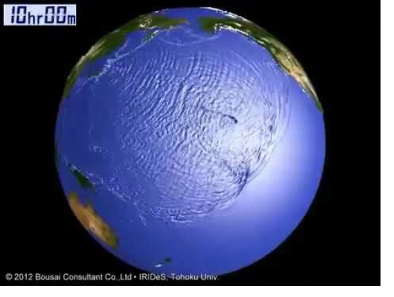
A computer extrapolation of todays Magnitude 7.4 earthquake in Japan, which generated a Tsunami, shows that Tsunami waves may be heading for Hawaii and the West Coast of North America according to the University of Japan at Tokyo.
The earthquake in Japan took place at 20:59 UTC. The computer model shows that Tsunami waves are presently traveling eastward in the Pacific Ocean from Japan, and are scheduled to begin striking the western coastlines of Hawaii at +7Hrs 33 Minutes.
That means Hawaii could begin seeing the effects of the Tsunami about ONE HOUR and 15 minutes from now (11:16 PM eastern US time or 6:16 PM local Hawaii Time)
According to the same computer model, Washington State and Oregon coastlines could start to be impacted at +9 Hrs 17 Min, with California beginning to get the waves at +9 Hrs 30 minutes.
Here is the computer model from the University of Japan showing the impact times. Folks in Hawaii would be well advised to get OUT of the ocean right now, and stay on higher ground for the next few HOURS. Folks on the West Coast would be well advised to get out of the water and move away from the coastline by 9:00 PM California Time tonight, for a few hours.
PACIFIC TSUNAMI WARNING CENTER
The US Government’s Pacific Tsunami Warning Center seems to believe the threat for Tsunami “has passed.” The University of Japan seems to disagree. In the interest of having the public FULLY INFORMED, we post the final message from the US Pacific Tsunami Warning Center below so you can decide for YOURSELF whether the folks in the Tsunami Warning Center or the University of Japan are correct!
SuperStation95 realizes this is directly conflicting information. We do not know which to believe. So we’re presenting both sources of information so the public can decide for themselves whether or not to seek higher ground.
817
WEPA40 PHEB 212308
TSUPAC

TSUNAMI MESSAGE NUMBER 4
NWS PACIFIC TSUNAMI WARNING CENTER EWA BEACH HI
2300 UTC MON NOV 21 2016

...PTWC FINAL TSUNAMI THREAT MESSAGE...


**** NOTICE **** NOTICE **** NOTICE **** NOTICE **** NOTICE *****

 THIS MESSAGE IS ISSUED FOR INFORMATION ONLY IN SUPPORT OF THE
 UNESCO/IOC PACIFIC TSUNAMI WARNING AND MITIGATION SYSTEM AND IS
 MEANT FOR NATIONAL AUTHORITIES IN EACH COUNTRY OF THAT SYSTEM.

 NATIONAL AUTHORITIES WILL DETERMINE THE APPROPRIATE LEVEL OF
 ALERT FOR EACH COUNTRY AND MAY ISSUE ADDITIONAL OR MORE REFINED
 INFORMATION.

**** NOTICE **** NOTICE **** NOTICE **** NOTICE **** NOTICE *****

THE TSUNAMI FORECAST IS UNCHANGED IN THIS MESSAGE.


PRELIMINARY EARTHQUAKE PARAMETERS
---------------------------------

  * MAGNITUDE      7.3
  * ORIGIN TIME    2100 UTC NOV 21 2016
  * COORDINATES    37.3 NORTH  141.6 EAST
  * DEPTH          10 KM / 6 MILES
  * LOCATION       NEAR THE EAST COAST OF HONSHU  JAPAN


EVALUATION
----------

  * AN EARTHQUAKE WITH A PRELIMINARY MAGNITUDE OF 7.3 OCCURRED
    NEAR THE EAST COAST OF HONSHU, JAPAN AT 2100 UTC ON MONDAY
    NOVEMBER 21 2016.

  * BASED ON ALL AVAILABLE DATA... THE TSUNAMI THREAT FROM THIS
    EARTHQUAKE HAS NOW PASSED.


TSUNAMI THREAT FORECAST...UPDATED
---------------------------------

  * THE TSUNAMI THREAT HAS NOW LARGELY PASSED.


RECOMMENDED ACTIONS
-------------------

  * GOVERNMENT AGENCIES RESPONSIBLE FOR ANY IMPACTED COASTAL
    AREAS SHOULD MONITOR CONDITIONS AT THE COAST TO DETERMINE IF
    AND WHEN IT IS SAFE TO RESUME NORMAL ACTIVITIES.

  * PERSONS LOCATED NEAR IMPACTED COASTAL AREAS SHOULD STAY ALERT
    FOR INFORMATION AND FOLLOW INSTRUCTIONS FROM LOCAL
    AUTHORITIES.

  * REMAIN OBSERVANT AND EXERCISE NORMAL CAUTION NEAR THE SEA.


POTENTIAL IMPACTS
-----------------

  * SEA LEVEL FLUCTUATIONS MAY CONTINUE ALONG SOME COASTS OF
    JAPAN OVER THE NEXT FEW HOURS.

  * HAZARDOUS TSUNAMI WAVES ARE NOT EXPECTED ANYWHERE OUTSIDE
    OF JAPAN.


TSUNAMI OBSERVATIONS
--------------------

  * THE FOLLOWING ARE TSUNAMI WAVE OBSERVATIONS FROM COASTAL
    AND/OR DEEP-OCEAN SEA LEVEL GAUGES AT THE INDICATED
    LOCATIONS. THE MAXIMUM TSUNAMI HEIGHT IS MEASURED WITH
    RESPECT TO THE NORMAL TIDE LEVEL.

                            GAUGE      TIME OF   MAXIMUM     WAVE
                         COORDINATES   MEASURE   TSUNAMI   PERIOD
    GAUGE LOCATION        LAT   LON     (UTC)     HEIGHT    (MIN)
    -------------------------------------------------------------
    MERA JP              34.9N 139.8E    2212   0.21M/ 0.7FT  08
    OFUNATO HONSHU JP    39.0N 141.8E    2207   0.28M/ 0.9FT  12

  * THE JAPAN METEOROLOGICAL AGENCY REPORTS TSUNAMI AMPLITUDES OF
    UP TO 0.90M ALONG THE EAST COAST OF HONSHU JAPAN.


NEXT UPDATE AND ADDITIONAL INFORMATION
--------------------------------------

  * THIS WILL BE THE FINAL STATEMENT ISSUED FOR THIS EVENT UNLESS
    NEW INFORMATION IS RECEIVED OR THE SITUATION CHANGES.

  * AUTHORITATIVE INFORMATION ABOUT THE EARTHQUAKE FROM THE U.S.
    GEOLOGICAL SURVEY CAN BE FOUND ON THE INTERNET AT
    EARTHQUAKE.USGS.GOV/EARTHQUAKES -ALL LOWER CASE-.

  * FURTHER INFORMATION ABOUT THIS EVENT MAY BE FOUND AT
    PTWC.WEATHER.GOV AND AT WWW.TSUNAMI.GOV.

  * COASTAL REGIONS OF HAWAII... AMERICAN SAMOA... GUAM... AND
    CNMI SHOULD REFER TO PACIFIC TSUNAMI WARNING CENTER MESSAGES
    SPECIFICALLY FOR THOSE PLACES THAT CAN BE FOUND AT
    PTWC.WEATHER.GOV.

  * COASTAL REGIONS OF CALIFORNIA... OREGON... WASHINGTON...
    BRITISH COLUMBIA AND ALASKA SHOULD ONLY REFER TO U.S.
    NATIONAL TSUNAMI WARNING CENTER MESSAGES THAT CAN BE FOUND
    AT NTWC.ARH.NOAA.GOV.

$$
SHOCK-WAVES REGISTERED IN USA!
NOTE: Japan Quake was so powerful, it was detected on 73 out of 76 Seisomographs operated by the US Geological Survey as part of its American Network Seismic of Sensors (ANSS), here in the UNited States! Basically, the effect of the Japan earthquake rang planet earth like a bell, and the shockwaves tgraveled literally around the world to be registered here in the USA!

by Newsroom


